Mid September in the Arctic is the time of seasonal change when it comes to ice. It is the change from melt and retreat of ice to freezing and advance. With that change, the Ice Navigator’s role begins to change from one of constantly looking for the next new opening,” Where can we get to now?, to what is closing and no longer open to this ship.
Since joining the ship, as expected, we have witnessed the usual retreat of the ice edge and continued melt of open water ice. Now in the third week of September ice charts are showing consolidation of ice within the pack and in some areas a gradual advance southward. Arctic Sea Ice Extent graphs are indicating a levelling off in the seasonal loss of ice and will soon begin to show the gradual increase in overall sea ice area for the Arctic as winter takes hold.
The Ice Navigator closely watches weather patterns and temperatures for systems and signs of weather that will contribute to increased freeze up and further advance of the pack. We now look for where we can not go and which areas are more progressively being closed to RV Mirai. In our present area of operation, sea surface temperatures remain resolutely above zero, while air temperatures are gradually dropping day-to-day and are consistently below zero. Remote from the gradual southward march of the growing polar pack, for the time being we are not at risk of ice formation around us.
The main polar pack ice edge has not retreated as far as in previous years. In 2010, the Mirai reached the furthest north for a non-icebreaking research ship in the Chukchi on 24 Sept of 79º11.4’N and in 2008 crossed the Canada Basin. This year the Canada Basin is completely covered with ice and the furthest north reached by the Mirai was 74º50’N on 07 September. The first two decades of this century have experienced some of the greatest loss in overall ice cover since reasonably accurate measurement began. After the huge loss in 2007 that shocked many and turned global attention to the Arctic, we have witnessed years of even greater overall loss in 2011 and 2012. This year, however, is clearly not in that league. On 17 September the total estimated area of sea ice was 4.8m km2, well above that of last years, but still less than the average ice cover in the decades before the turn of the millennium.
This year is not necessarily a sign of “global cooling”, it is merely a sign of continued variability. Yes, there has been a gradual reduction in overall ice area in the Arctic but there will continue to be good ice years and bad ice years, and even in a good ice year the mobility of Arctic ice still requires a caution in those that choose to operate here. Two adventurer voyages that set off with high hopes of running through the Northwest Passage this summer were forced to abandon their attempts due to ice and severe weather. Regardless of the reports of successful one off voyages with support of heavy nuclear icebreakers, this ocean is not yet fully open for business and far from “ice free”. The Arctic is still an ocean that is covered by ice, much of it heavy multi-year ice, eight to nine months of the year.
Capt David (Duke) Snider
Ice Navigator
RV Mirai
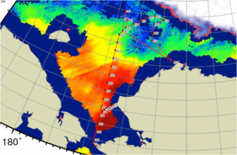
Image: Examples of ice charts in use onboard RV Mirai