Passage planning in the Arctic often has that added dimension, ice. Like any routine passage plan, the navigator begins with a strategic overview, where are you coming from where are you going, how do you get there. With the basic navigational data in hand, charts, sailing directions, meteorological and current data, the navigationally safe waters are determined. The Ice Navigator then factors in small scale/large area ice charts indicating current and forecast coverage to determine how ice conditions may affect the plan, taking into consideration what ice conditions a vessel of this ice class can safely operate in. Even the best daily ice analysis charts and forecasts are not foolproof. The Ice Navigator adds his years of experience and knowledge to make more fine tuned forecasts, considering what the actual conditions are in the area around the ship, and how winds and currents will further affect the actual ice conditions to select the best routing. A detailed description of the process is covered in chapter 6 Passage Planning in Polar Ice Regions in the book Polar Ship Operations – A Practical Guide, published by the Nautical Institute
With a research vessel program like we have onboard Mirai, there are often more options of destination and route than a conventional commercial ship may have. That is, if we can’t go here, we can go over there instead. The Ice Navigator briefs the Captain and senior science personnel daily on day to day ice conditions then a new plan is developed as priorities and conditions change.
The Chief Scientist lays out his priorities, and with ice overlaid the Ice Navigator will advise which is the most likely to be achievable given ice conditions. Once approved by the Captain the next cruise plan is sent to the Second Officer to lay off. As the vessel nears it’s objective time and distance wise, and as new information is obtained, the shorter term strategic plan is updated, and the tactical plan is firmed up. The feedback loop is more frequent in ice passage planning, to make allowance for the constantly changing ice conditions.
This morning was one of those days when ice was a primary factor in developing the next cruise plan once the work at FP is completed on the 25th. After last night’s ice briefing the CS worked on developing three possible scenarios for the cruise plan post Fixed Point. The Captain, Chief Officer, CS, Assistant CS and I went over the three plans, current ice conditions and forecast ice.
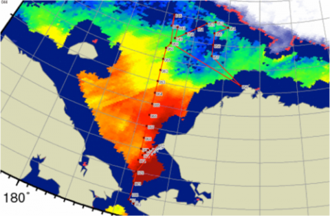
My recommendation was straight forward. Given the present ice conditions, the subsurface mooring named CAP was already encumbered by ice on the edge of the polar pack ice edge. With the NOAA and TOPAZ forecasts indicating even further advance southward of the ice edge and likely coverage by at least 6-8/10ths old ice by 25/26 September the first option though possible if conditions change, was unlikely. Plan B allowed for appraisal of the conditions as we head north towards 74ºN to a position which is presently predicted to be in open water but may be north of some ice of 1-3/10ths coverage. Southerly winds expected over much of the next week would help keep the more open ice clear of our target. If necessary we could simply cancel that northern station then head south to open water and once clear head towards the stations back at 74ºN but further east and presently in open water and likely to remain so. If we were to go with Plan C, leaving the stations at 74ºN 162ºW till after Barrow, there is greater likelihood those stations would then be denied to us by ice cover by the time we got to them.
At the end of the discussions it was decided that Plan A was highly unlikely and was shelved. Plan B would be the plan of choice at present, but conditions of course would be monitored over the coming days before final decision. The feedback loop would continue in the coming days as conditions change and new data is received. Things change in the Arctic.
Capt David (Duke) Snider
Ice Navigator
RV Mirai
Image: AMSR2 snapshot with Chief Scientist’s proposed plan B