The final two days in the vicinity of Point Barrow have been about moorings. Three sub-surface moorings are placed along the Barrow Canyon from about 26nm offshore in the north westerly line. BCE, BCC and BCW are in place to monitor variations of volume, heat and fresh water fluxes from Pacific Water entering the Arctic Ocean. The head of the Barrow Canyon is a prime area for biological activity, so sensors are also added to measure temperature, salinity, dissolved oxygen and dissolved oxygen. In some cases whale “voices” are recorded as well.
The mooring lengths from anchor to top mooring float range from about 64m to 244m in length. Each mooring is rigged with disposable scrap steel anchors, connected first to acoustic releases which when triggered release the entire mooring string above the anchor. Depending on the depth and the particular data to be collected, along the mooring string may be Conductivity Temperature and Depth (CTD) or Conductivity Temperature (CT) sensors; Current meters; sensors for dissolved oxygen, chlorophyl and turbidity; upward looking sea ice thickness profiler; echo sounding fish profiler; and whale “voice recorder”. At the very top is a steel float about 1m in diameter, and again, depending on the mooring length, other steel or plastic floats may be rigged in the length of the mooring.
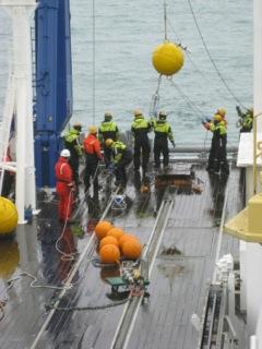
Generally the moorings stay in place of 12 months, but can remain viable for much longer. The three moorings recovered on 05 September were placed about the same time last year, and all things being well, will be recovered next year about the same time. The recovery operation is relatively straight forward. The ship travels over the site of the mooring placement and using a transducer over the side communicates with the acoustic release. On signal, the release does its job and the mooing comes to the surface, quickly identified by the bright yellow or orange floats. Using the Mirai’s RHIB, a messenger line is secured to the top float and the mooring string is drawn in over the stern through the A-Frame, pausing to detach the valuable instruments as they come onboard. From appearance on surface, to last gear onboard for the 74m BCE it took 40 minutes to recover, and BCC which is the longest at 244m took 70 minutes.
The replacement moorings were deployed on the 6th, in virtually the same positions to maintain data comparison continuity. Each mooring is assembled just prior to deployment, the JAMSTEC techs carefully noting the serial numbers of each component. With exact precision the bridge crew move to position the ship over the mooring location as the deck crew deploy the mooring over the stern. First out is the top float that pulls the remainder of the mooring as it is sequentially passed over the stern. Just shy of the position the anchor is attached to the mooring then swung over to wait for the command from the bridge. BCE went into position at 0840 and was followed through the day by BCC just prior to lunch, and BCW in the early afternoon.
Next year Mirai will be back to recover and deploy replacement moorings. For now, we turn north for the ice edge and to work the Northwind Abyssal Plain. ice information received indicates a good possibility that ice strengthened Mirai can occupy the stations that up till now were ice covered and outside the limits of her light ice class.
Capt David (Duke) Snider
Ice Navigator
RV Mirai
Photo: The top float of Barrow Canyon East mooring goes over the stern of RV Mirai