In my first blog from RV Mirai during the 2014 voyage I wrote of the primary mission: the coordinated collection of meteorological observations from an international fleet of Arctic research ships and a number of Arctic shore observation stations. We are now well into the coordinated observation period and have been at “Weather Station Mirai” at 74º45’N 162º00’W, about 225 nautical miles northwest of Point Barrow. I find it interesting that my Coast Guard career began in 1979 as a deckhand onboard CCGS Vancouver, one of two 404ft “weatherships” that maintained station on “weather station Papa” in the North Pacific up until 1981 and today I sail as Ice Navigator on one of a new generation of weather observing ships far north in the Arctic Ocean.
This morning our solitary existence was broken as CCGS Amundsen passed to the north of us on her mission, presently focused on retrieving valuable subsurface observation moorings and deploying replacements. Amundsen has also been contributing to the Arctic Research Collaboration for Radiosonde Observing System (ARCROSE) 2014 study by launching two radiosondes per day.
The ARCROSE concentrated meteorological observation cruise came out of studies of several events in past years, one in which detailed observations of a polar low development were obtained from icebreaker Polarstern in 2009, another of an Arctic cyclone observed by RV Mirai in 2010, and the fixed point observations made by RV Mirai in 2013. During each of the events there was a lack of data to support the single point observers other than some shore based meteorological observations. The lack of additional data clearly hindered researchers in their data assimilation phase in order to improve weather forecasting models. The ARCROSE 2014 experiment aims to fill in the data gaps. The ultimate objective is to improve sea ice forecasting along the future sea routes and forecasting of extreme meteorological events in the Arctic.
Mirai is the only Arctic operating ship equipped with automatic radiosonde launching equipment and Doppler weather radar. A Doppler radar uses reflectivity to estimate the water amount in the atmosphere and Doppler velocity to estimate wind. The Doppler radar scans continuously 24 hours a day. Since taking up station we have been launching radiosondes every three hours. In addition, water column samples are taken 4 times daily using the CTD/rosette and expendable CTDs (XCTD) are deployed during radiosonde launches that do not coincide with rosette deployment. The water column data is then matched against the atmospheric data for additional comparative analysis.
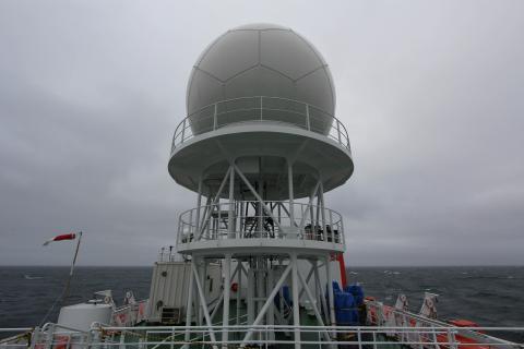
We are working in the Arctic for the first time with Mirai’s newly installed Doppler radar. As Masaki Katsumata explained, the new system installed to replace the original radar is mounted almost 2m higher than the previous unit, well above the funnel on the port side aft, removing a blind sector that occurred with the older unit. The new system uses a larger 4m scanner that is dual polarized, which means it transmits and receives both conventional horizontally polarized beam and vertical polarized. Where a horizontal polarization can provide target width only, the vertical component allows for a measure of target height thereby providing a more definitive shape. This allows for a more accurate algorithmic calculation of rainfall rate. It is hoped that the system will be better capable of determining differences between rain, ice, snow and graupel. The HYdrometer VIdeo Sonde (HYVIS) radiosondes are being launched periodically to ground truth the new radar comparing the video pictures obtained with the radar return analysis.
Ashore, supercomputers are already at work on the data that is being collected from the Canadian, Swedish, German, Japanese and Korean ships (since I first wrote on this mission Korea’s icebreaker “Araon” has joined the project and is launching two radiosondes per day), American aircraft and the shore stations. It’s a pretty hefty coordination of data collection, and more importantly, data assimilation at the end of it all.
A far bigger picture will be available to the researchers that undoubtedly will assist in improving prediction models, and make things safer for mariners intending to operate in the Arctic region. Too often, rapidly forming and devastatingly powerful polar lows suddenly pop into existence, un-forecast and wreaking havoc on unsuspecting mariners. Better understanding of sea ice formation, movement and degradation would certainly be important to develop as well in my opinion. Collecting real time data to enable far more reliable and realistic forecasts of extreme polar events and sea ice are a worthy scientific endeavour.
RV Mirai’s newly installed Doppler Weather Radar

